Chapter 4: Operational Flight Plan (OFP) Format
Not intended for real world pilotage. For entertainment purposes only. Consult your manufacturer, operator, and/or local regulatory body for all operational requirements.
The default OFP format that vAAL uses for vAMSYS's Dispatch via SimBrief method is, unsurprisingly, the AAL format. If an alternate OFP format is desired, selecting another OFP format is possible if the OFP is generated manually at SimBrief.
Some excerpts from the AAL OFP format follow highlighting commonly sought information for FMS/FMC/MCDU initialization.
Flight Plan/Dispatch Release Header
This section contains the basic release information. In this example:
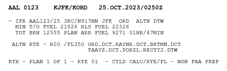
Flight released IFR for American 123 on the 25th day of the month, aircraft number 3KC/N917NN from JFK to ORD, alternate airport is DTW, minimum takeoff fuel (legal minimum fuel for takeoff) is 21,826 pounds; release fuel (ramp fuel plus any extra fuel) is 22,326 pounds, total fuel burn (enroute plus taxi fuel) is 12,555 pounds, and planned arrival fuel (reserve + captain’s/dispatch additional fuel + alternate + hold fuel + ferry/tanker fuel + extra) is 9,271 pounds or 1 hour and 47 minutes duration.
The ALTN RTE line gives the cruising altitude and route to take you to the alternate. R00 will likely never be used by SimBrief as it denotes a stored company route code. Following that we see the cruise altitude for the alternate flight plan, FL350, and the alternate flight route itself: ORD.DCT.RAYNR.DCT.BRTMN.DCT.TAAYZ.DCT.PORZL.RKCTY2.DTW
The final line is not particularly relevant to the simulation environment; it denotes which stored company route the OFP is based on and denotes a controlled (by dispatcher) calculation of route and altitude.
ICAO Flight Plan
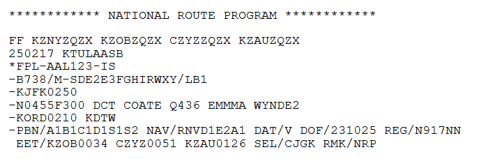
This section contains the ICAO flight plan.
The top line, beginning with FF, and the coding which follows provides flight plan forwarding information to various ATC sectors for flight following for real life flights; this is not relevant to flight simulation
“250217” is the time of OFP generation, the 25th day of the month at 0217z, KTULAASB is not relevant to flight simulation, it's the eight digit address from which the flight plan was filed
"FPL-AAL123-IS": the flight plan for American 123 is IFR with Scheduled air service
Aircraft type is B738 with a /M medium wake turbulence class, equipment code follows
Flight departs KJFK at 0250Z
N0455F300 represents a TAS of 455 knots at FL300; the proposed route of flight follows
Flight to KORD has an estimated time enroute of 2 hours 10 minutes, alternate is KDTW
PBN/ denotes navigational capabilities
NAV/ informs ATC of SID/enroute/STAR RNAV capabilities. PBN and NAV are both standardized ICAO codes.
DOF is date of flight (YYMMDD). REG is aircraft registration.
EET/ line is the estimated elapsed time to cross FIR international boundaries; this is not required for domestic operations, but SB seems to give it for all OFPs. EET/KZOB0034 denotes it will take 34 minutes to reach Cleveland Center's airspace, CZYZ0051 denotes it will take 51 minutes to reach Toronto Center's airspace, and so on
SEL/ is SELCAL code
RMK/ is any other plain language remarks deemed necessary
Flight Plan/Dispatch Release Body
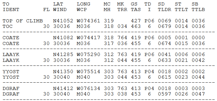
This section, shown partially above, gives detailed route information.
TO / IDENT: This column gives the next waypoint’s name and identifier. This makes a bit more sense with a VOR as the top line would be the name of the VOR and the bottom line the identifier (e.g., Volunteer / VXV”)
LAT / WIND: Latitude / WIND given as a two-digit direction and three-digit velocity (e.g., 30036 = winds at 300 at 36 knots)
LONG / WCP: Longitude / WCP is the wind component; P = tailwind, M = headwind, speed in knots (M036 = 36 knot headwind)
MC / MH: Magnetic Course and Magnetic Heading
MK / TRR: Mach Number / TRR is the highest actual terrain heigh (in hundres of feet) between route waypoints 5nm left and right of course
GS / TAS: Groundspeed / True Airspeed, both in knots
TD / I: Temperature Deviation from ISA / Turbulence Indicator (numbered from 0 to 7)
- 0 = Smooth
- 1 = Occasional light
- 2 = Light
- 3 = Light to occasional moderate
- 4 = Moderate
- 5 = Moderate to occasional severe (Mach will be reduced to penetration speed)
- 6 = Severe (route blocked)
- 7 = Extreme turbulence (route blocked)
SD / TLDR: Segment distance and total distance remaining
ST / TTLT: Segment time and total elapsed time
SB / TTLB: Segment fuel burn and total fuel burn (including taxi)
Flight Plan/Dispatch Release Corrections

This section provides figures to allow corrections to portions of the calculated flight plan based on changes in weight followed by two lines of additional information relevant to the overall flight plan.
Line 1: For a ramp weight increase of 1,000 lbs, there is a corresponding increase of 0 minutes (TIME P00), 51 lbs of additional fuel burn (FUEL P0051), an increased flight cost of $51 (COST P0023), and an initial alitude of FL300 (FL 300).
Line 2: The same as line one, but in reverse, for a ramp weight decrease of 1,000 lbs.
Lines 3 and 4:
- RWT: Planned ramp weight in pounds (145,391 lbs)
- PLD: Planned payload in pounds (29,890 lbs)
- GND: Planned ground time in minutes (20 minutes taxi out, 8 minutes taxi in)
- Q: A time adjustment in minutes based on historical planning, a negative number would indicate an average early arrival. This is probably not simulated by SimBrief
- CI: The planned cost index
- SKD: Scheduled departure (0250z) and arrival (0515z) times
- BIAS: Percentage of trip fuel added to account for aircraft performance deterioration
- AVG WIND DIR/COMP: Average wind direction (276 degrees) and component (P = tailwind, M = headwind, e.g., 53 knot headwind) on the planned route
- AVG TD: Average temperature deviation (P = plus, M = minus, e.g., +7C) from standard atmosphere on the planned route
Regarding cost indeces, some SimBrief aircraft profiles incorrectly do not allow you to set a Cost Index, such as the MD-80 profile, whereas add-ons for that aircraft type might accept a Cost Index - the Leonardo MaddogX does. Please reference the CI information earlier in this manual to set your CI manually.
Please reference the Flight Planning section of the FOM for recommended Cost Indices for vAAL fleet types.
Fuel Block
This section provides fuel information, some of which is located earlier in the OFP.
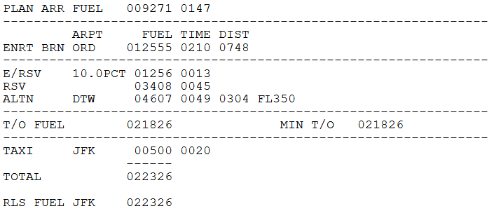
PLAN ARR FUEL is the amount of fuel in pounds (9,271 lbs) the flight should arrive at the destination with, along with the amount of time that amount of fuel represents (1 hour and 47 minutes).
ENRT BRN provides the amount of fuel needed to reach the destination airport (ORD), given as the amount of fuel in pounds (12,555), the amount of fuel in time (2 hours and 32 minutes) and the distance of the planned flight route (748 nm).
E/RSV is the enroute reserve fuel, also called contingency fuel in SimBrief. As stated earlier in this document, vAAL requires 10% enroute reserves. For the example OFP this corresponds to 1,256 pounds of fuel, which corresponds to 13 minutes of endurance.
RSV is reserve fuel given in pounds (3,408) and time (45 minutes). As stated earlier in this document, vAAL requires 45 minutes of reserve fuel for domestic flights and 30 minutes for international (flag) flights.
ALTN is the amount of fuel required to reach the alternate airport (DTW) via the planned alternate flight routing. This is given in fuel amount in pounds (4,607), time (49 minutes), distance (304 nm), as well as the planned cruise level for the alternate flight plan (FL350).
T/O FUEL and MIN T/O fuel represent the minimum amount of fuel that the flight can legally take off with (21,826 pounds). These two values can differ in the real world due to ferry/tanker fuel, etc. (T/O FUEL would be greater with ferry fuel onboard).
TAXI is the amount of taxi out fuel at the departure airport (JFK) given in pounds (500) and time (20 minutes). Note: taxi in fuel at the destination is included in the ENRT BURN numbers.
TOTAL is the total amount of fuel that all of the above amounts sum up to (22,326 pounds).
RLS FUEL is the amount of fuel, given in pounds, that the flight is released with and that the crew should load on board at the departure airport (JFK). This will usually be the same number as the TOTAL line in SimBrief OFPs.
On-Time Analysis

This section compares the scheduled block time versus flight plan time for taxi-out, airborne, taxi-in and total to determine on-time status. This does not come from any schedule data provided by vAAL; we do not know what SimBrief is referencing to populate the scheduled block time.
SKDBLK: Scheduled block time data; TXO: taxi-out in minutes (20 minutes); AIR: airborne time in hours and minutes (1 hour and 57 minutes); TXI: taxi-in time in minutes (8 minutes); and TOTAL: TX + AIR + TXI time in hours and minutes (2 hours and 25 minutes).
FLIPLN: Flight plan time data; TXO: taxi-out in minutes (20 minutes); AIR: airborne time in hours and minutes (2 hour and 10 minutes); TXI: taxi-in time in minutes (8 minutes); and TOTAL: TX + AIR + TXI time in hours and minutes (2 hours and 38 minutes).
ENDURNC: equivalent endurance time in hours and minutes (3 hours and 58 minutes) of the RLS FUEL; ADJ: adjustment to the endurance time in minutes per 1,000 lbs difference in RLS FUEL (11 minutes per 1,000 lbs). This line actually should not display on domestic flight plans like the one used in this example, this line is part of an ETOPS information block that only shows when ETOPS Planning is ticked in SimBrief.
Remarks / NAT Tracks
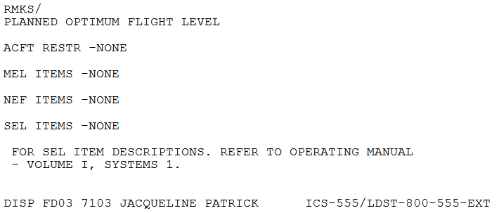
The only line in this section that is relevant is the RMKS/ line, which is where any text in the “Dispatch Remarks” field in SimBrief appears. This can be used however the pilot finds most helpful. Everything else in this section is autogenerated and largely irrelevant.
The pages between this section and the Load Closeout on the final page of the PDF are also autogenerated and of varying usefulness to flight simulation. The first section after the Remarks block is the Weather Forecast which follows standard METAR and TAF formats and provides weather for the departure, arrival, and alternate airports, along with enroute weather at several flight levels.
Following the weather, when relevant, is information regarding NAT tracks/PACOTs, and then a lengthy NOTAMs section. The NOTAMs will mostly not be relevant to the simulation environment, but pilots may choose to respect any information in this section as they wish, so long as it does not conflict with instructions given by online ATC.
The final section of the OFP before the Load Closeout contains weather forecast maps and wind maps for the planned flight route, which should be reviewed as part of the flight preparation process.
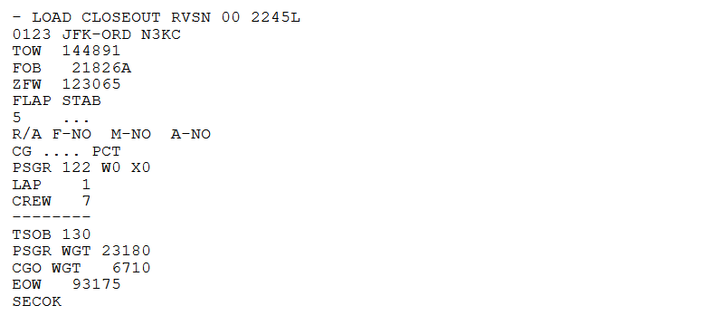
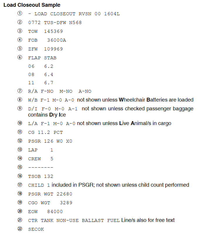
Load Closeout